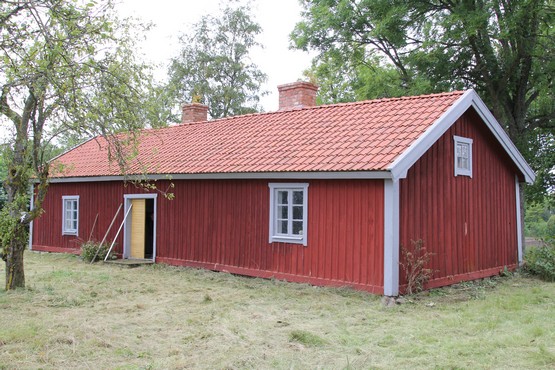
Broby Prästtorp 2015. Photo: Bernd Beckmann
The abandoned parish of Broby, the disappeared church and the associated remaining property Prästtorp are located in Vadstena parish (formerly Strå parish).
Around 1100, King Inge and his wife Helena founded the monastery in Vreta and gave it the following properties
(Nils Ahnlund in Historisk tidskrift 1945):
• 4 ottungar in Lilla Vreta,
• 2 ottungar in Bro,
• 3 ottungar in Brunneby,
• 4 ottungar in Hucklum,
• 2 ottungar in Mollotorp,
• 2 ottungar in Broby i provinsen Dals härad.
(ottung ≈ 12 tunnland (barrel of land))
Barrel of land (tunnland) as a measure of area is a Nordic unit of area corresponding to the area sown with one barrel
of seed, which was determined to be 4,936.6 m² in the 1630s.
Broby estate is first mentioned in a possibly forged letter in 1208 when the abbot of Alvastra Henrik is said to have bought and exchanged parts of Broby and the neighbouring village of Åby (lund) from a Sone Tjelvasson (DS 134, 134a). The authenticity of the letter has been questioned but was confirmed by the knight Knut Jonsson in 1330 (DS 2781), who then owned land in the neighbouring village of Älvestad (DS 1921). In the 1440s Vadstena Abbey owned a property in Broby and a property in Åby(lund).
Already in the letter of 1208 the vicar of Broby, Johannes, is mentioned. It is easy to imagine that the owner of the Broby manor had a manor church built, perhaps in the early 12th century, when several of the other churches in Dals härad were built (Project Sweden's churches). The vicarage is apparently identical to the current Prästtorp, which is located immediately west of the cemetery and was separated from Brobygården to create the priest's livelihood. Prästtorp is described as a settlement in Staffan Helmfrid's thesis Östergötland "Västanstång": Studien über die ältere Agrarlandschaft und ihre Genese.
From the middle of the 16th century until the end of the 17th century, the Crown owned Prästtorp and is listed as a priest's home in regional documents and other material. In 1698, the owner of the neighbouring Åbylund manor, the headman Jacob Du Rees, applied to acquire Prästtorp, ¾ mantal, which was granted (Länsstyrelsens i Östergötland arkiv, Landskontoret G IIIf:10, p 1148ff). Since then, both Prästtorp and Broby former cemetery belong to Åbylund, which today is owned by the Eke-Göransson family. Sometime during the 16th or 17th century, the information varies, Broby parish was incorporated into Strå parish. Broby church may have been demolished at the same time. In Landskapshandlingarna for the year 1600 you can read that: "Broby is deserted". The church remains were excavated by RAÄ in 1997 and 2007. No depiction of the church is known. On the oldest map (geometric land register) from 1633-34, the church is missing, but Prästtorp is listed as a crown estate. This should mean that it was already demolished before this time.
Prästtorp has not been used permanently since the 1960s, but periodically as a summer house, although not in recent years. Vadstena museiförening has in co-operation with Östgöta Dals ek. for., which works for a living countryside in the southern part of Vadstena municipality, has rented the house from the owners. The intention is to make Prästtorp and the site of Broby church a cultural focal point and attraction with a strong emphasis on the site's ecclesiastical history and significance. Already today, mass is held here every year because the neighbouring plot is the site of Broby's lost church, marked by the owner with a wooden cross. Probably the site of Prästtorp is the old vicarage in Broby and through analysis we know today that the current house was built in the 1780s and 1810s. By preserving the building, adjacent to the Broby church plot, and developing the site into an attraction and meeting place, its importance as the centre of a now completely disappeared parish will be highlighted as an important, but until now almost completely unknown, part of the history of the church in the area. Local (regional) identity and cohesion will be strengthened. The public will be able to access and experience the site and the new knowledge generated by it. It may be possible to furnish the building in 2016.
Text: Claes Westling

Broby Prästtorp 1948

The oldest preserved map from 1633-34 of Prästtorp, 1 homestead (D on the map), Åby (grove) (C), 4 ½ homesteads and Broby millyard (A), ½ homestead. Broby old cemetery is the place where the letter D stands next to Prästtorp.
By surveyor Johan Larsson Groth, 1633-34. The original at the National Archives, Stockholm.
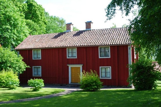
Hovs Skräddaregård 2010. Photo: Patricia Renström.
The village of Hov grew up because workers were needed at the grand manor Hofgården. The farmhouses were built along a village street where Skräddaregården is marked on a map dated 1638. Skräddaregården is the only structure from this first settlement that remains in its original location after the 1832-1833 land reform (laga skifte) in Hov.
The oldest part of the current residential building was built in the early 18th century and originally consisted of one room. A kitchen was added and the house became a single cabin (enkelstuga). Then a floor was added, which can be dated by a log labelled 1776. Finally, the cottage was extended into a two-storey semi-detached cottage (parstuga), probably in the mid-19th century. The cottage is tall and narrow, typical for agricultural properties on the Östgötaslätten (Östgöta plains) from this period.
The existing outbuilding is shown on the 1832-1833 shift map and has been a brewhouse. Previously probably a sheepfold.
The threshing lodge has been built together with a barn. It has been moved a few times, the last time probably in connection with the legal shift.
There have also been 2 wing buildings. The eastern wing was a trade shed from the late 1800s until about 1930 when it was demolished. The west wing was demolished in the 1950s. Its foundation stones remain in front of the house.
Although the estate was permanently inhabited until 1947, it was not modernised. It therefore has great cultural value and was declared a listed building in 2009. Skräddaregården (tailor's farm) has been inhabited by the same family since the 1690s when the ancestor Sacharias came to Hov from Harstad, Väderstad. The last private owner, Astrid Kajling, born Ericsson, donated the property to Hovs Hembygdsförening in 1982.

Village of Hov 1638

Village of Hov 1718

Village of Hov 1832

Skräddaregården around 1910, in the centre Karl Eriksson. Photograph: Unknown

Skräddaregården from the east, unknown date, but before the 1930s, when the east wing was demolished. Photograph: Unknown

Map of 1810
Hovs Skräddaregården is part of Hovs hembygdsförening. The opening hours can be found under activities on the homepage.
www.hembygd.se/hov
Broby Prästtorp is part of Vadstena Stadsmuseum (town museum). E-Mail .